By Robin Whittle
Several articles have been written in the Deben Magazine concerning the river wall defences1,2,3,4. This article concentrates on the immediate need for action on the river wall of Flood Cell 1: Bawdsey to Ramsholt.
The clay river walls of the River Deben have provided landowners and the local community with grazing marsh and arable land for the past five hundred years. During this time the walls have been raised by about 0.6m/century to compensate for sea level rise and clay wall settlement (see Figure 1).

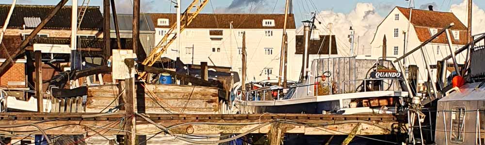
Figure 1: River wall at Ramsholt being enhanced in 2015
Where breaching occurs, the wall is either eroded down to saltmarsh level or, where there is no saltmarsh, down to the embanked fresh-water marsh level. The latter is very difficult and extremely costly to repair, usually requiring the use of helicopters. Overtopping is not necessarily damaging to a wall providing the wall is largely level and the overtopping is less than 200mm over a landward slope of not less than 1:2. (see Figure 2).
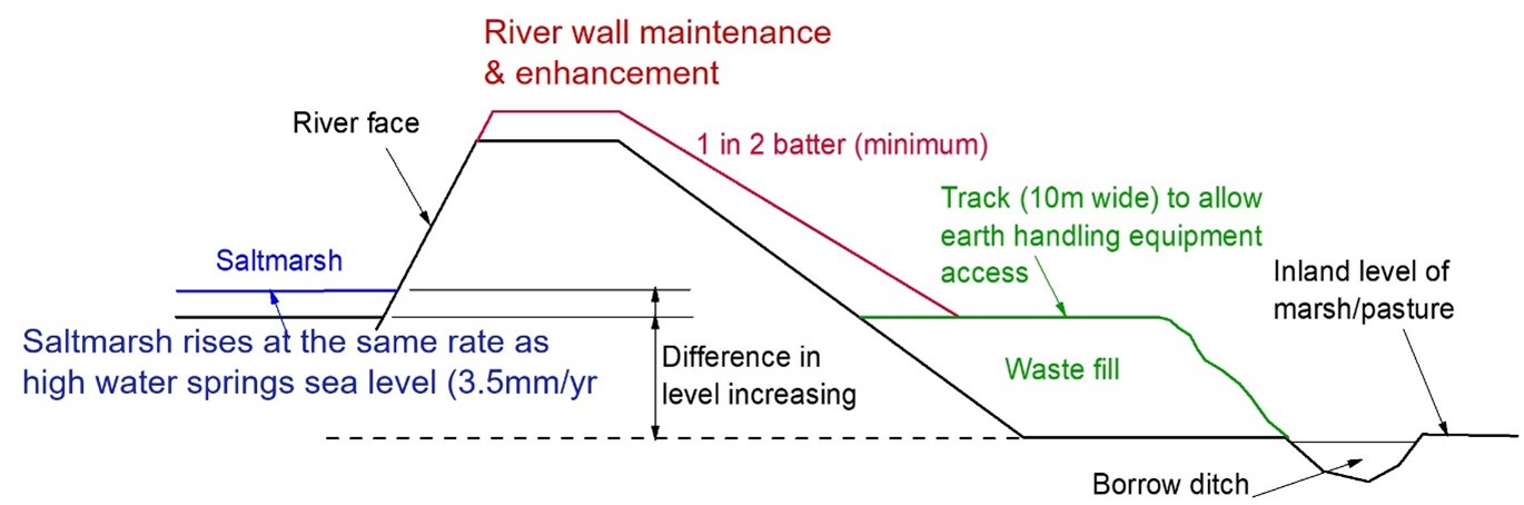
Figure 2: Ideal section through river clay wall
Figure 3 shows the plan layout of the River Deben Flood Cells.
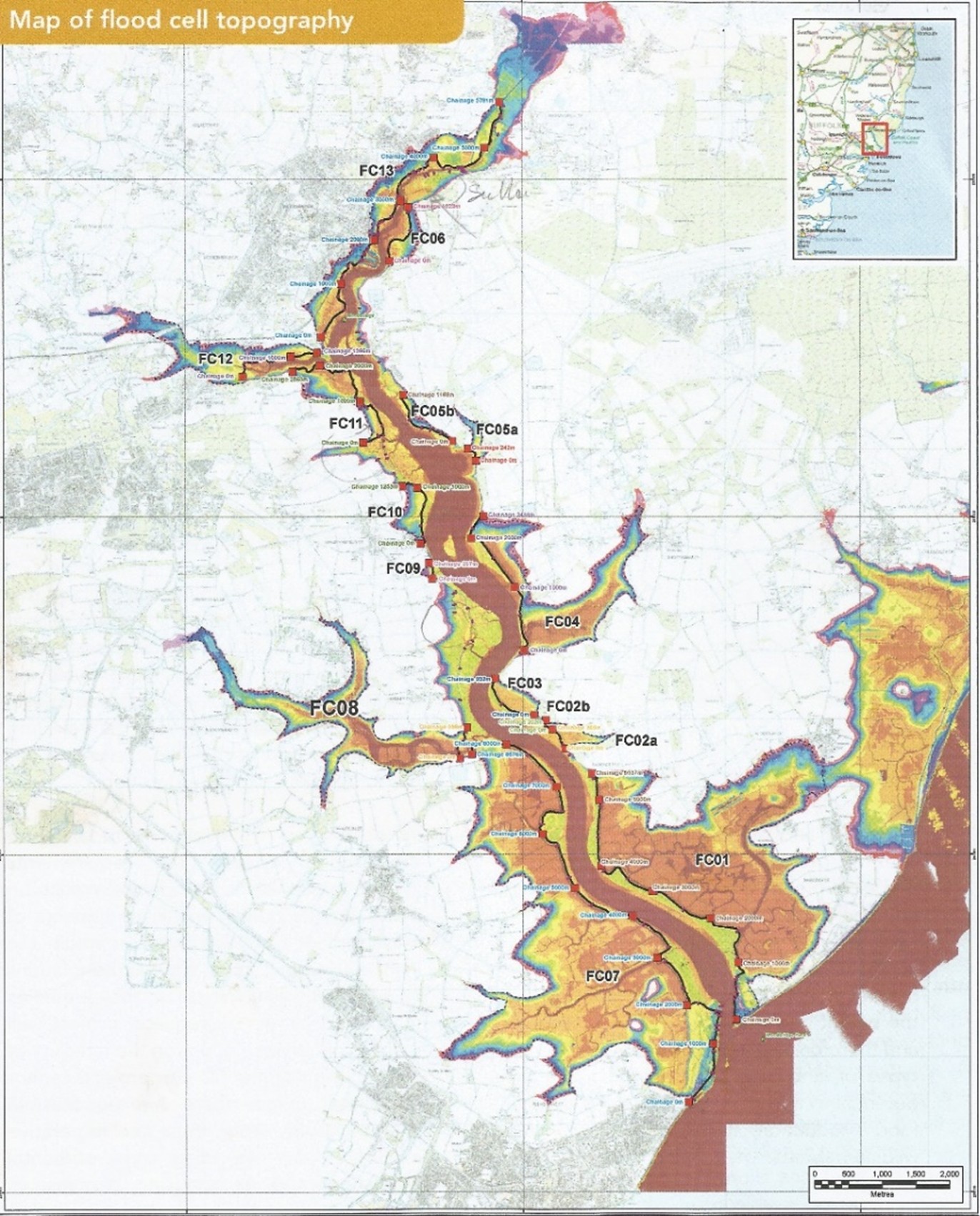
Figure 3: Layout of the River Deben Flood Cells.
If breaching occurs in the walls of either Flood Cell 1, Bawdsey to Ramsholt (6Km long), or Flood Cell 7, Felixstowe Ferry to Kirton Creek (12Km long), the whole community will suffer. Each of these flood cells have an embanked area of around 500ha (over a 1000ha in total).
Flood Cell 1 wall is particularly vulnerable to breaching, since its height is lower than all the other walls in the Deben. This wall has not been raised since the the1953 floods when it was brought to a level of 3.6mOD (above Ordnance Datum). Since then, parts have settled 200mm to the level of 3.4mOD, just equal to that of the 2013 storm surge. If this wall is breached the land will be flooded for much of the tidal cycle, making it almost impossible for land-based equipment to make repairs. If not repaired, the tidal flow through the breaches will increase the tidal prism (the tidal volume and river velocity) by up to 30%, seriously increasing the erosion and flood risk to the down-stream defences at Bawdsey and Felixstowe Ferry.
In 2016 the Deben Estuary Partnership produced a Deben Estuary Plan emphasising the importance of maintaining the river walls. Unfortunately, there was no mention of how the walls should be managed or funded.
The Environment Agency (EA) have no legal duty to maintain the river walls. The landowners are responsible for maintaining their river walls. The EA, using its permissive powers, can carry out maintenance, improvement, or construction work to manage flood risk and protect the environment but do not have a legal obligation to maintain the defences even for urban areas. However, the EA do have legal powers to monitor river wall maintenance. This is provided through Flood Defence Consent. One reason for this is to ensure that when a landowner of a flood cell wall wishes to raise their wall, the EA will analyse the effect that this will have on other flood cells – and will limit the increase in height to minimise flood risk to other cells. This can lead to a complete breakdown of any maintenance plan. For example, a landowner could decide to raise a river wall to maintain a reasonable flood risk for 50 years. However, the EA is likely to reject the application because it causes an increase in the flood risk to other cells. A situation that would stop all wall raising.
Funding for wall maintenance of the Suffolk estuaries is not simple – a combination of several funding streams have been used in the past i.e. landowners, public, Council, IDB, EA etc. The fairest way to achieve funding would be to create a tax on the community (Council Tax). This method has been used successfully for the Fen Lands. However, it would take time to set this in place for the river estuaries and we have little time left to save Flood Cell 1. We need funds now! Severe storm surges occur every 7 to 14 years. The last one occurred in 2013, 11 years ago. The next one must be imminent.
Comment by Co-Chair of the River Deben Association:-
Robin Whittle raises some important and well-researched issues in his Journal article.
As Robin points out, the ultimate responsibility for maintenance of the Flood Cell 1 wall lies with the Landowners. As a mark of progress, they are currently in discussions with the Environment Agency, the Deben Estuary Partnership and the River Deben Association about an agreed way forward. There will be further communication once decisions are taken – expected within two months.
Colin Nicholson
References:
- Simper R: River Deben Flood Defences: The Deben No. 64 Spring 2022
- Whittle R: Hold the Line – River Deben Wall Defences: The Deben No. 61 Autumn 2020
- Wain P. The Deben River Walls: The Deben No. 59 Autumn 2019
- Whittle R. Maintenance of the River Wall to Flood Cell 01 on the River Deben. Journal of The Deben October 2021.
Annex A
Maintenance of the Suffolk River Walls
This note, prepared by Richard Steward and Robin Whittle, proposes the following protocol for the maintenance of clay walls in Suffolk estuaries.
Most of our clay walls were built some 500 years ago to provide grazing marsh and arable land. Over this time the walls have been raised by about 600mm/century by the landowners and the local community to offset sea level rise (350mm/century) and settlement (250mm/century). Since 1930 this work has been carried out by River Catchment Boards, Regional Water Authorities, National Rivers Authority and, from 1996, by the Environment Agency (EA).
The Environment Agency has taken responsible for protecting urban areas (land with dwellings) but following an eight-fold increase in the EA’s benefit cost ratio, the responsibility for maintenance of many river walls has been passed back to the landowners and community. During the last ten years local estuary plans have been produced by Estuary Partnerships representing the community, landowners and local and Government bodies. However, despite many years of meetings and discussions, there has never been an agreed protocol for determining the height of the river walls. The following is a proposed solution for a ‘50 year Rebuild Interval’ using observed data that can be applied to all East Coast Estuaries.
- Normally the EA’s East Anglian Coastal Modelling Study would be used to assess wall heights for Suffolk estuaries. Fortunately, we have actual data using Leica GPS RTK measurements of debris lines taken at each river entrance a few days after the 2013 storm surge. We propose to use these measurements as they are an accurate record of the highest surge since 1953. Entrance Surge Heights: Blyth 3.0mOD, Alde & Ore 3.3mOD and Deben 3.4mOD.
- Add SLR and Settlement Adjustment at 6mm/yr from 2013 to the end of the 50-year Rebuild Interval e.g. 6mm/yr x (2075-2013) = 0.37m.
- Add 0.2m where there are no saltings in front of the wall or add 0.3m where the wall directly protects property.
- Flood Cell rebuilding order of priority. 1) Protection of lives, 2) Protection of property by value, 3) Protection of land by value 3) Protection of river tidal prism by Flood Cell tidal volume.
Note: Currently, none of the world’s tide gauges show a discernible acceleration trend over the last 136 to 173 years.
See four of the long-term NOAA tide gauge records below: – 173 years at 1.44mm/yr at Wismar, Germany, 173 years at 1.69mm/yr at Maassluis, Netherlands, 160 years at 0.78mm/yr at Aberdeen, Scotland and 136 years at 0.80mm/yr at Fort Denison, Australia.
- https://tidesandcurrents.noaa.gov/sltrends/sltrends_station.shtml?id=120–022
- https://tidesandcurrents.noaa.gov/sltrends/sltrends_station.shtml?id=150-061
- https://tidesandcurrents.noaa.gov/sltrends/sltrends_station.shtml?id=170-011
- https://tidesandcurrents.noaa.gov/sltrends/sltrends_station.shtml?id=680-140
RTW & RRS 18/04/2025
Robin Whittle
Robin Whittle is a civil engineer who worked on power stations and dams in his early working life. In 1968 he joined Ove Arup and Partners and since then has provided specialist advice for reinforced, pre-stressed concrete and structural design from within Arup Research and Development. He retired in 2001, although continuing work as a Consultant. His main pastime pursuits have centred around sailing and, in the latter years pottery, with his own studio. He enjoyed many years sailing 505 dinghies and attended championships all over the world. In the mid-nineties his wife Gillie declared that dinghy sailing was at an end for her. Together they chose a more relaxed boat, the Cornish Shrimper, in which they could explore coastal waters. He is a member of the Felixstowe Ferry and Waldringfield Sailing Clubs.