By Colin Nicholson
Introduction
Water Quality is a fast moving, high interest area for the River Deben Association. Since the last RDA Journal Article (‘Water Quality Update’ January 2025), Waldringfield Bathing Water Designation Area has achieved (announced 25th October 2025) a second year of clear run 20/20 [Excellent] measurements across the May-September Environment Agency (EA) bathing season.
Two significant projects are now in their start-up phases, each with a major focus on water quality:
The Deben Climate Centre’s Four River’s initiative (link) across the Deben, Blyth, Alde and Ore and Waveney “A new three-year co-funding agreement between East Suffolk Council and Deben Climate Centre… The aim will be to restore degraded ecosystems, support nature recovery and test a range of different flood alleviation measures.”
The Essex and Suffolk Rivers Trust has initiated the ‘Recovering the Deben: Source to Sea’ (link) “an ambitious project that aims to restore the land, water, and nature throughout the River Deben catchment and estuary”
This latest journal article focusses on trying to resolve the debate on just how many outfalls there are between Martlesham Creek to Wilford Bridge. The answer is Fourteen (caveated as usual as there is more to learn, and there is an extra one inland at the Deben Yacht Club (DYC) dinghy park). Below for those interested is a little bit more detail of how they work.
Information through the desktop
A certain amount of deskwork is possible, with multiple sources of information to consult
- The Rivers Trust Sewage Map which has a list of Combined Storm Overflow (CSO) outfalls and their most recent spill information
- Surfers Against Sewage (SAS) have recently launched a new Safer Seas & River Service App (UK-wide sewage map showing over 17,000 monitored discharge pipes). You can check when and where sewage is being released, and exactly who’s responsible, with data for the past year.
- Anglian Water Services (AWS) has a map (link) which shows live jobs helping to shed light on what is happening locally with regards to issues, (although not routine maintenance)
There is also an AWS internet page ‘Storm overflows – Frequently asked questions’ (link) for more information.
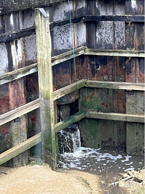
One misconception is that storm overflows output raw sewage into the Deben. However, what should be happening is that should the system overflow in times of high rainfall (to avoid the system backing up into people’s houses,) the waste should be screened through filters permitted by the EA, so no solids, wetwipes etc. should be going out into the estuary. But this waste is still considered raw sewage as there has been no processing, e.g. settling out and bacterial activity.
October Estuary Walking Expedition – ‘Outfall Safari’
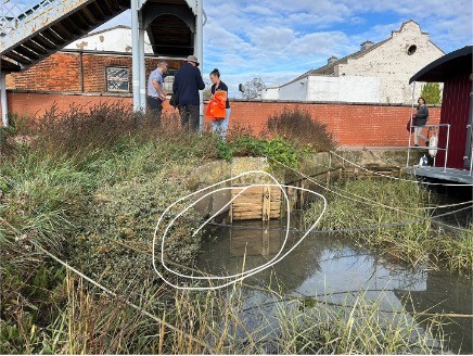
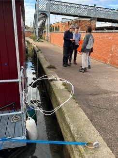
But the best way to ascertain what outfalls are where was by undertaking a water’s-edge expedition which took place towards high tide, in thankfully good weather (with Storm Benjamin coming through the night after!) on Wednesday 22nd October 2025. Demonstrating fruitful cooperation, representatives from the River Deben Association (RDA,) Deben Climate Centre (DCC,) and AWS walked the bank of the Deben Estuary from Martlesham Creek to Wilford Bridge, (with thanks to Martlesham Creek Boatyard for parking).
The focus of the expedition was mapping all the outfalls and sluices which belong to AWS and the EA. Our AWS colleagues shared maps of each of the Combined Storm Overflows (CSO’s) on their network and we discussed recent spills and how this had happened; DCC are now monitoring these spills and their impact on a regular basis.
It transpired during the expedition that assets not belonging to either AWS or EA are involved. It would have been advantageous to involve East Suffolk Council (ESC) who are involved and there are also private assets. DCC and RDA subsequently walked with ESC around the Boating Pond/Tea Hut area to the railway station.
Three areas of specific interest arose during the safari: –
- The source of one unexplained polluting drain, already monitored by DCC, near Woodbridge railway station, will be followed up
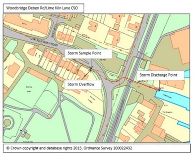
- The “Deben Road/Lime Kiln Lane” AWS CSO was found to be incorrectly placed (although correctly labelled) on publicly available on-line maps. Work is scheduled to change the mapping coordinates to make it appear at its correct location.
- The stream alongside Kingston Field, high flow and sometimes contaminated with E.coli, also drew attention, with ESC contractors on-site at the time – repairing drains by the boating pond, long blocked by tree roots…
Beautiful weather for the safari made it difficult to understand how these hidden and irregular storm overflow issues happen. At least wild swimmers and other recreational users can be grateful for the estimated 7-17 million litres (per neap and spring tide) daily tidal exchange diluting the water of the estuary which the participants on low-flow rivers cannot benefit from.
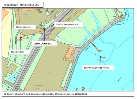
The walk was literally the calm before the storm – Storm Benjamin – the night after the walk and into the morning, saw heavy rain across Suffolk. The volume of water triggered spills for the CSO’s in Woodbridge; one at the “Station Road CSO” started at 11.09 pm and according to the Event Duration Monitoring (EDM) data lasted for over 5 hours, (these monitors have a history of sticking open it seems). As of 14th December 2025, all AWS permitted Storm Overflows will have monitors fitted.
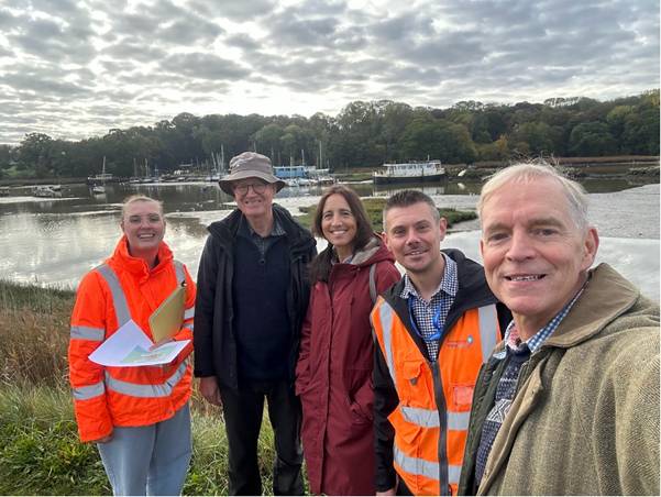
L-R: Zoe Borthwick (AWS Bathing and Shellfish Water Strategy Manager); David Findley (DCC Water Quality Lead): Siobhan Horner-Galvin (DCC 4 Rivers Project Manager) Gary Hodgetts (AWS Catchment Adviser); Colin Nicholson (RDA Co-Chair)
What is laid out in this Journal article illustrates a complex situation. However, with raised public interest and awareness these matters are beginning to move in a positive direction. AWS is swift in responding to issues, particularly if one can get to the right department and the EA has expanded its monitoring organisation, both for inspecting AWS assets and a separate group for investigating incidents. The Deben’s SSSI, SPA and Ramsar status as well as the Waldringfield Bathing Water Designation Area means that AWS and the EA are responsive in trying to resolve issues.
The surface water and foul water network maps are being brought out, increasingly understood and action being taken
Colin Nicholson
November 2025
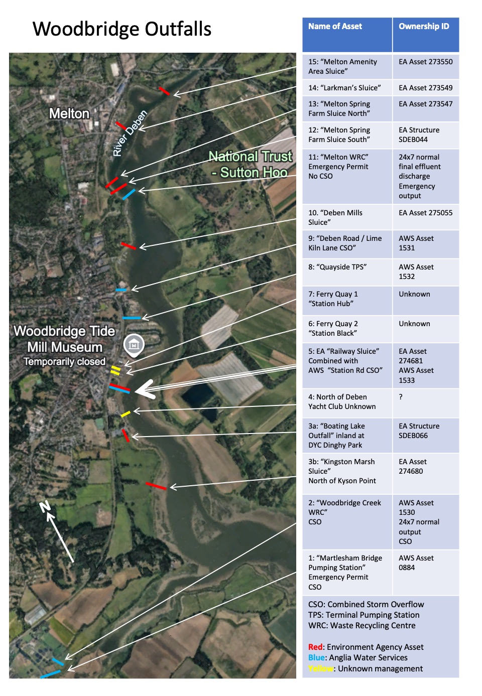
Main points of discovery, from South to North: –
2: Woodbridge Creek WRC: [5 events* to date in 2025]
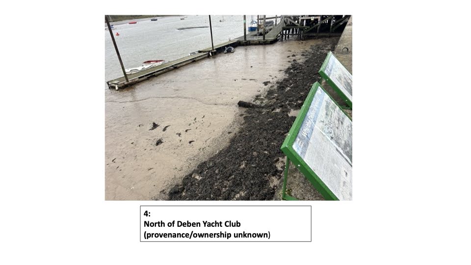
| There is 24×7 treated outflow (which will have high E.coli, but this is to be expected). As stated above, all storm overflows are screened and inspected by the EA and should thus be waste water only with no solids. The expedition found an additional un-mapped outflow below the WRC, the purpose of which was not clear. AWS are investigating. |
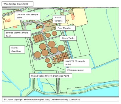
Next year, AWS will be carrying out a catchment survey to ascertain the wider impacts of Woodbridge and Melton WRCs and the results of this survey might trigger investment in a further £multi-million tertiary treatment phase using UV light to eliminate any viruses and bacteria in the final output.
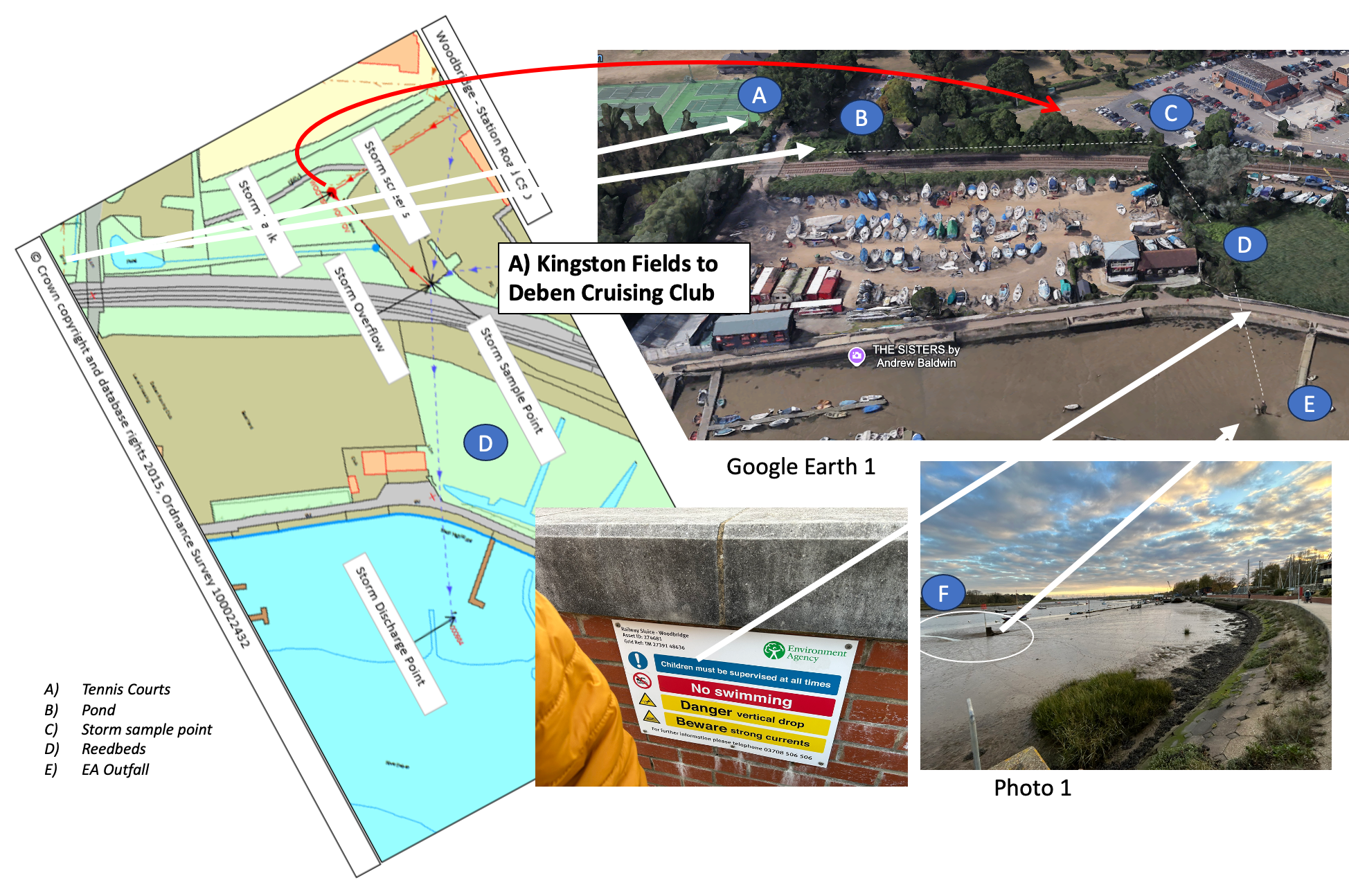
Woodbridge Boating Pond/Tea Hut:
The fast-flowing brook running between the tennis courts and Jetty Lane is thought to start from a spring in Fen Meadow. However, testing across recent years has discovered periodic high levels of E.Coli. This suggest there are “misconnections” (houses or sewers directly connected to the brook) upstream, but it seems it will be nigh on impossible to discover where, let alone take action. Following the safari, DCC tested the water quality and a sample taken showed 60 colonies per 1ml. This is very high given the significant flow rate and has been reported to the EA as the periodic overflows to the boating pond/Tea Hut area will almost certainly be polluted with E.coli.
East Suffolk Council (ESC) should be congratulated for carrying out significant recent work in this area, including clearing leaves (blockages cause the brook to overflow into the Boating Pond area). When flowing normally, the brook splits in two: –
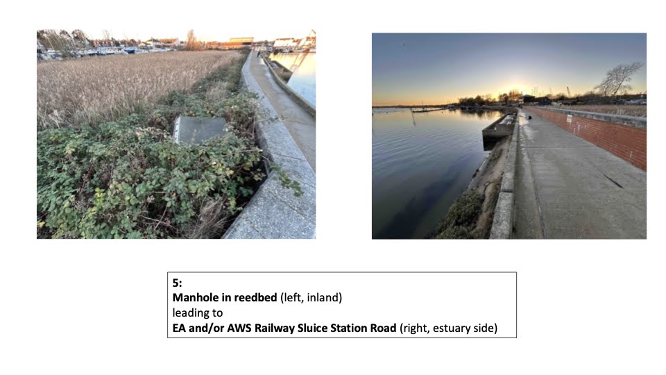
- to a pond on the other side of Jetty Lane between the railway and the Deben car park, recently cleared by ESC, and ultimately flows out via the reedbeds next to the Woodbridge Cruising Club through the EA “Railway Sluice”
- to pipes under the boating pond/Tea Hut area from which ESC were removing significant tree roots at the time of the safari. There has been a manhole cover in the bushes by the newly tarmacked Jetty Lane that pops when there is significant rainfall.
The exact mapping of drainage pipes in this area is unknown, but the ultimate destination of most of the surface water appears to be via an Environment Agency (EA) sluice “Boating Lake Outfall” between the Deben Yacht Club dinghy park into the nearby reedbeds and thence into the Deben through the EA “Kingston Marsh Sluice.”
EA assets are on a 6 monthly inspection cycle with the last visual inspection of “Kingston Marsh Sluice,” “Boating Lake Outfall” and “Railway Sluice” being carried out in the summer of 2025 and the next due in January 2026.
5. “Station Road CSO”: [35 events* to date in 2025]
9. “Deben Road/Lime Kiln Quay CSO”: [45 events* to date in 2025]
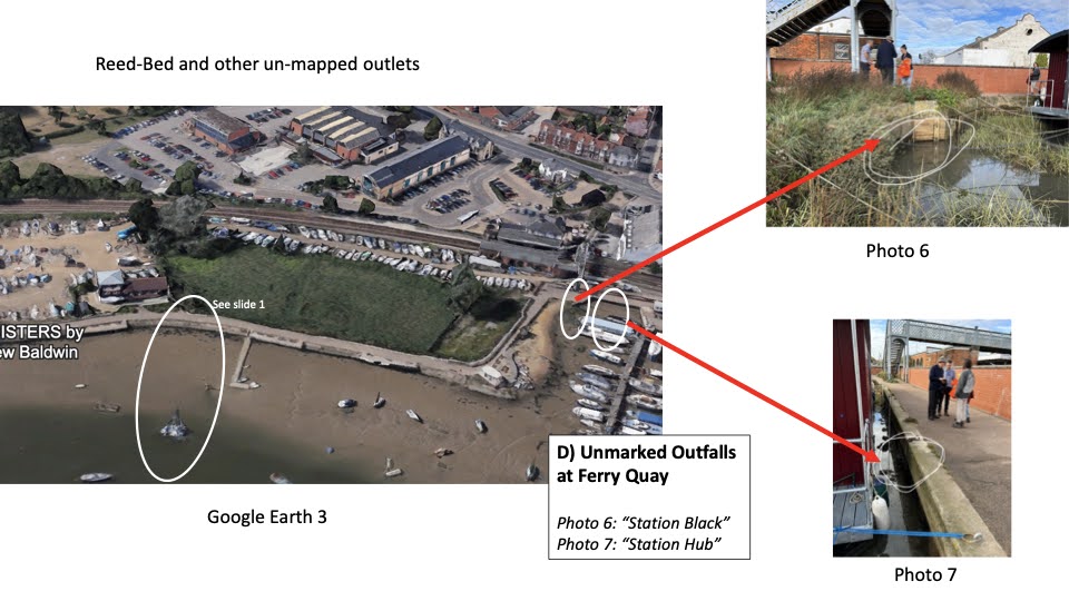
6./7. Ferry Quay outfalls: (locally known as “Station Black” and “Station Hub”)
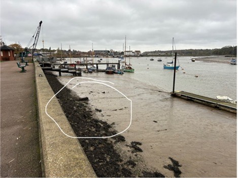
During their homework for the safari, AWS discovered that this AWS outfall, whilst correctly labelled, has been incorrectly mapped, being represented on public facing maps as co-located with the “Station Road CSO.” In reality and on AWS’s internal network maps, this outfall is at Lime Kiln Quay, on the other side of the railway from the corner of Elmhurst Park. After a couple of years of raising the issue, a long-standing blockage in this CSO at Deben Road has been cleared and it is now functioning correctly.
“Station Black”
“Station Hub”
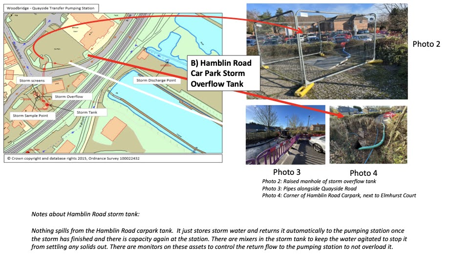
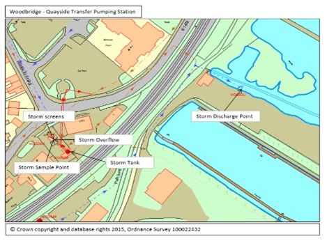
8. “Quayside Transfer Pumping Station CSO”: [52 events* to date in 2025]
11. “Melton WRC” outfall:
EOs are not covered by AWS’s EDM monitoring programme. EO’s are covered by a different set of alarms that alert AWS of any discharges, which are responded to immediately. It is likely that EO’s will, in time, be added on to the Storm Overflow maps.
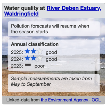
Waldringfield Bathing Water Designation Area: rated [Good] for the second year running
The Environment Agency’s 2025 review of Bathing Water areas was released 24th November 2025. Nationally, “87% of bathing waters rated ‘Excellent’ or ‘Good’ as new reforms come into law.” https://www.gov.uk/government/news/87-of-bathing-waters-rated-excellent-or-good-as-new-reforms-come-into-law
Waldringfield’s Bathing Water Designated Area, was rated [Good] for the second year running. In more detail, for 2025, all 20 out of 20 readings across the bathing season rated [Excellent]. But the statistics methodology requires that 2x 2023 [Poor] results should still to be taken into account. These seem to be associated with the September 2023 super-high-tides and the consequent washing down of the higher parts of the beaches with dog and bird waste, human faecal waste being ruled out. More information can be found on the RDA website at https://www.riverdeben.org/about-the-river/bathing-water-quality/

| Bathing Water Designation brings other benefits. The Environment Agency takes an active interest in the water quality for wild water swimmers and on 26th September 2025 issued an advisory notice against swimming due to the leak of diesel from an abandoned boat (link) .Notices were put up and removed when the threat had passed. The Deben Climate Centre also tests regularly at Waldringfield including outside the May-September bathing season and have found occasional spikes in pollution which are reported to the Environment Agency with a view to identifying causes. |

And finally:
While you’re out, if you spot a pollution incident (e.g. foul smells , nasty stuff in the river, dead fish etc.) any illegal activity or anything else, please report it immediately to the environment authorities. Their hotline is open 24 hours a day: Phone 0800 80 70 60
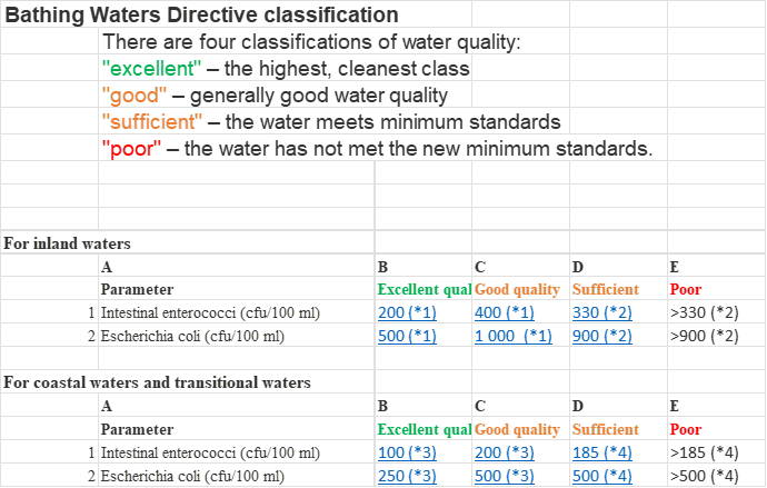
Further information on Bathing Water Quality Classifications:
Note: *
The Surfers Against Sewage (SAS) App map illustrates “Events” but these include “Maintenance” events which may not be pollution events. The National Storm Overflow Map (which is ran by Water UK with water company’s data) says the following:
“Occasionally monitors may display as offline or under maintenance. This could be caused by a fault but could also be because the monitor or surrounding infrastructure is being maintained or upgraded. Monitors could also be unavailable due to poor or losses of network coverage meaning the monitor can’t communicate – this is a particular problem in remote areas. Water companies aim to get monitors working again as soon as they can. Sometimes fixing monitors may take some time if the location is difficult to access (for example if it is on a busy road and approval is required from the local authority before it can be accessed).”
See Slide Show (below, click right and left arrows) for more detailed information and pictures of outfalls and sluices: –