By Jan Harber
OS Explorer 197 Ipswich, Felixstowe & Harwich
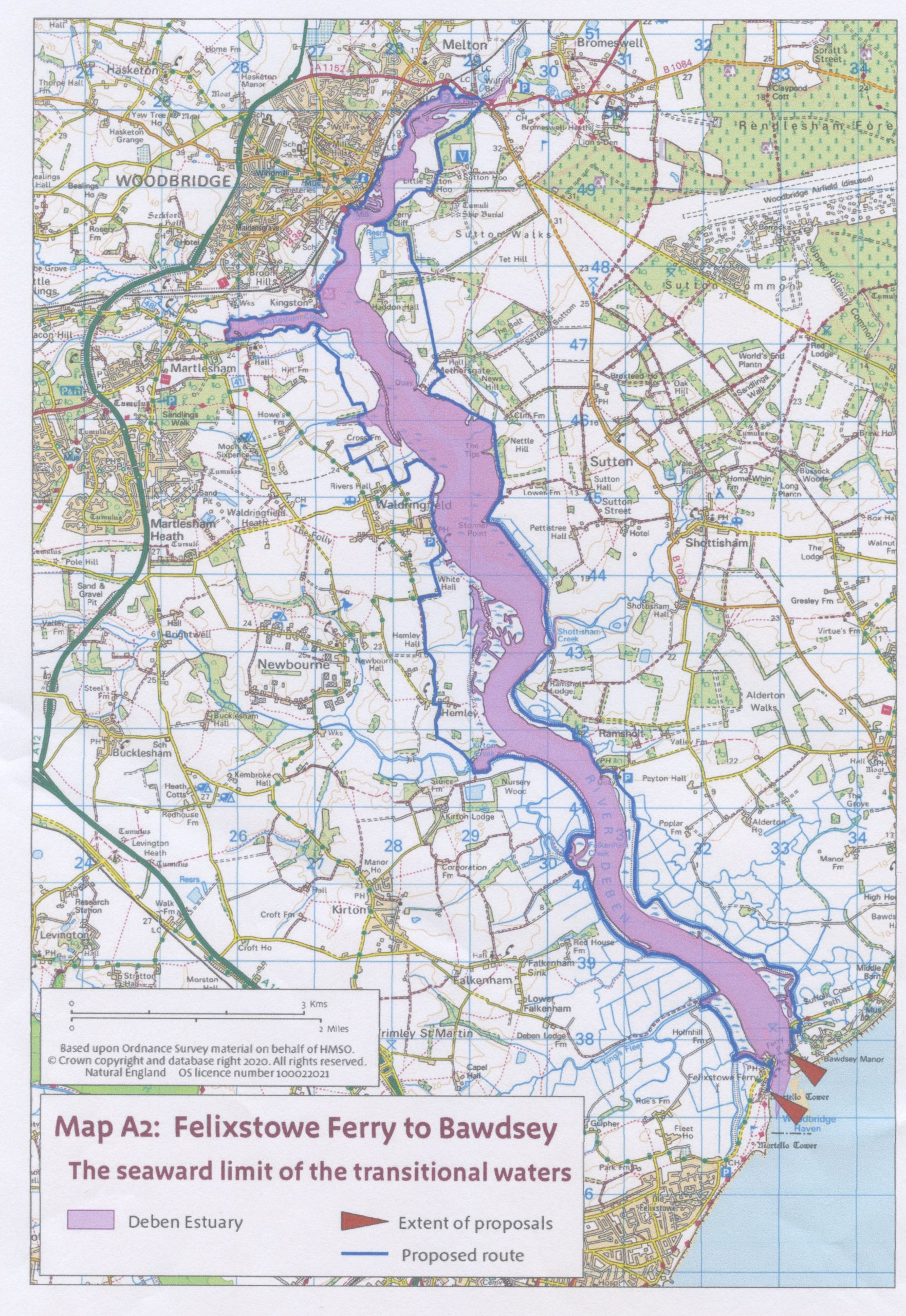
In September 2025 sections of the recently-created King Charles III England Coast Path were opened along both banks of the Deben: from Bawdsey to Wilford Bridge and Wilford Bridge to Felixstowe Ferry. See map with the whole route marked in blue. Much of the Coast Path route is along existing rights of way. However, there are three ‘new’ sections which Judy and I decided to investigate this autumn.
Wilford Bridge to Ferry Cliff
The first, and we think most significant, is on the Sutton Hoo side from Wilford Bridge to Ferry Cliff. The new route has the huge benefit of eliminating the need to walk along the busy B1083 for over a mile before reaching the Sutton Hoo site. And even further to reach the river at Ferry Cliff. We explored this section of the Coast Path as an ‘out and back’ (about an hour each way) from the free car park by the level crossing at Melton Riverside.

Walk along the wall to Wilford Bridge

Low Water below Wilford Bridge. Could this be the remains of a much earlier ford just visible in the mud
From the car park follow the new signs with the National Trails acorn logo, and walk along the seawall to the road at Wilford Bridge, turn right onto the pavement, and cross the bridge. You soon come to the next set of signs pointing you up a previously private drive, now turned into a public footpath. The tarmac drive, known locally as The Lower Track, passes through the mature trees of Brown’s (presumably Basil) Planting, to Little Haugh. Here the ‘new’ route connects with the existing foot path network around the National Trust Sutton Hoo site, up the hill on the left.

View from the Lower Track across the river to Limekiln Quay and Robertsons

Mrs Pretty’s house at Sutton Hoo, glimpsed from the Lower Track at the bottom of the hill
Initially the route is not beside the river but there are good views across to Melton on the other side. One reason for the Coast Path not following the shoreline is that the coastal margin here is one of the few remaining areas where the narrow mouthed whorl snail can still be found. I am not making this up.
Details about the snail, and much much more, can be found on www.debenestuarypartnership.org where there is an overview of Natural England’s statutory reports to DEFRA on the original proposals for the England Coast Path. The website www.nationaltrail.co.uk also features the King Charles III England Coast Path but it is nowhere near as useful as the Deben Estuary Partnership website.
The National Trust has signed permissive paths that enable you to leave the Lower Track and meander on an optional loop across the meadows towards the river near Little Haugh.

National Trust’s permissive route around Riverview Field

Path beside the meadow towards the sea wall. Masts in Tidemill Yacht Harbour in the distance
Follow the original foot path turning right at Sutton Hoo Farm, between the dwellings and towards the river wall with meadows on your right. The existing path close to the foreshore along the foot of Ferry Cliff used to be a bit of a scramble but considerable improvements have been made in the form of wooden bridges and steps. At the top of two flights of steep new steps the footpath eventually joins the bridleway around the edge of the trees on Ferry Hill. Here there are some wonderful views over the river.

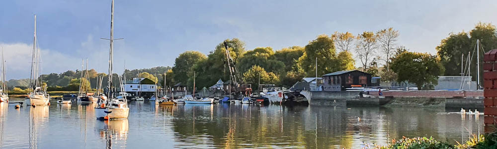
The Tidemill Yacht Harbour entrance from the foot of Ferry Cliff

The Tidemill from near the top of Ferry Cliff
This bridleway would have been a busy thoroughfare in the olden days when it was the main route from the Wilford Peninsula to the Woodbridge ferry crossing. From here we retraced our steps back to Wilford Bridge but the Coast Path continues in a southerly direction to Bawdsey, via Methersgate and Ramsholt.
Martlesham Wilds to Waldringfield
We knew that this inland part of the Coast Path had been planned to avoid the breach which, in recent years, has made it impossible to walk the sea wall between Martlesham and Waldringfield. We imagined it would be a boring route around field margins far from the river. We were wrong. The land here is, for Suffolk, almost hilly, so the path is undulating, with higher ground that results in some lovely views of the river from time to time. This part of the King Charles III Coast Path is a marked improvement on what went before.
We parked in the Martlesham church car park. The small parking area is used by churchgoers, walkers and visitors to Suffolk Wildlife’s Martlesham Wilds. On Sundays it may get busy, so be prepared to park along the road side.
The Coast Path can be joined at the bottom of Sluice Wood near Martlesham boatyard but to pick up the start of the ‘new’ bit we walked the footpath that heads towards the river from Martlesham Hall. Signs were somewhat lacking on Suffolk Wildlife territory but eventually we discovered a recently-built footbridge with an arrow and hand-written sign saying ‘Coast Path Waldringfield’. After following our noses along a grassy track to a small decoy pond, we came to our first glimpse of the river and then found an official signpost, one of many, at every turn all the way to Waldringfield.

New bridge with home-made sign

Official Coast Path sign

Small pond with view over the river towards Haddon Hall

Owl box in an oak tree
Along tracks fringed with newly-installed fences and gates we left Martlesham Wilds behind and descended steeply to the large decoy pond in the little valley opposite Methersgate Quay. It was high water so the saltings were flooded and this made the river seem to be nearer, although the cottage (see photo) at Methersgate was nearly a mile away. The unimpeded view across the river here is made possible by nearly a mile of breached sea wall which lets the tide in twice a day.

Looking across the flooded salt marshes towards the cottage at Methersgate from the Decoy Pond
Then it was uphill on the other side of the valley, with several more viewpoints along the way. The track runs alongside arable fields, becoming narrow when it turns inland and then back again towards the river, alongside a drive to Cross Farm.
At this point, about a mile and a half from Waldringfield, we turned back. The rest of the Coast Path down to Felixstowe does not include any new bits, as far as we know, so we didn’t feel the need to explore any further. From here towards Waldringfield the path circuits another couple of fields to come out on a bend in a lane. Turn left, leaving the road, and follow the signs to rejoin the seawall path into Waldringfield.
The ‘new’ bit of the Martlesham to Waldringfield route is about three-and-a-half miles from the seawall at the entrance to Martlesham Creek to the Maybush Inn.
Bawdsey to Ramsholt
We got very excited when we saw that the section of new Coast Path marked on the map appeared to promise access to the seawall beside the Deben between Bawdsey and Ramsholt. There has never been any public access here before.
After leaving the car in the free car park (with toilets) at Bawdsey, we crossed the road to be confronted by a splendid new National Trails sign, embellished with a curlew. It told us we could now ‘enjoy three miles of brand-new access beside the River Deben’. And that we must ‘… stick to the path, keeping to the base of the river wall… to avoid disturbing the birds.’

Notice at the start of the walk from Bawdsey
Ahead on our left stretched a very new Kiwi stock fence, to the right was a dyke and a large ploughed field. On the other side of the fence was the seawall, over which we could see nothing. Oh well, we thought, maybe the path will go on the wall later…

Fence and wall on the left, dyke on the right. You can’t lose your way!
Three miles on and we had almost reached Ramsholt, still no access to the wall and only one little glimpse, framed with barbed wire, of the river. The fence continued all the way, with additional strict notices telling us to ‘stick to the path’ – the equivalent of saying ‘Keep Out.’ We did see some wildlife, a marsh harrier, a kestrel and some partridge. We also heard what were probably Cetti’s warblers in the reeds, which looked lovely in the autumn light. The only decent view of the river came through the trees as we walked up the little hill to the car park.

New gates and bridge near Ramsholt

Almost at Ramsholt – at last we saw a glimpse of the river

In front of of the Ramsholt Arms the Coast Path takes briefly to the foreshore before continuing on dry land.
Unless you patronise the Ramsholt Arms, you will have to pay to use this car park. As we had no desire to retrace our steps back to Bawdsey, we were glad we had paid and parked another car here earlier.
Access for the England Coast Path route has clearly been beset by difficulties in protected areas such as SSSI, SPA and RAMSAR. Wherever there are salt marshes and mud flats with over-wintering and breeding species of birds and other sensitive wildlife, there are going to be ongoing access problems.
Despite our disappointment with the last stretch we explored, there is no doubt that the other newly-opened routes we investigated are a distinct improvement. Thanks to the King Charles III England Coast Path, some previously inaccessible tracks have been made available along or not far from the banks of the River Deben.

Janet Harber
Janet Harber is the daughter of Jack Coote, known to many as the author of East Coast Rivers, which Jan took on after his death. She is an RDA member.